Transerve Technologies uses Geospatial Technology to map COVID-19 density zones

This system works on predictive analysis and uses layers of geospatial data to track, monitor, analyze and visually represent them into data stacks. These data stacks will help in route optimisation in COVID positive zones that will help businesses in making statistically driven decisions.
More Innovations
It’s been quite the year, and (spoiler alert) there’s no guarantee that 2022 will be any less disruptive. Find out how to future-proof your business as we enter the post-pandemic era by reading TrendWatching’s 22 for ‘22 forecast, featuring trends and opportunities that will help you navigate 2022 and beyond.
Explore our key insights and learnings from reviewing over 1,000 COVID innovations. From common traits among the best and most inspiring COVID innovators to the various new COVID-triggered trends and business opportunities for the new normal.
Arup collaborated with the Liverpool city council and design-led greening consultancy Meristem Design to develop 'Liverpool Without Walls' scheme. The modular elements slot together to create outdoor seating areas made from hardwood, screened from each other with plants and perspex glass.
Called “The In Car Care Unit”, the drive-through clinic is conceived to be a midway point between tele-health, where doctors might miss critical symptoms, and physical clinic visits. It is designed to be easily deployed in hospital parking garages and would take up 60 feet of space (the amount of space between two columns in a hospital parking lot). The components of the unit could be prefabricated elsewhere and installed quickly on site.
WaterWipes is supporting new and expecting parents during lockdown by hosting virtual expert-staffed panels and providing community interaction through its Early Days Club virtual community.
The face mask, called 'C-Mask,' can be worn over regular, fabric-based masks. It connects to an app via Bluetooth, enabling it to transcribe speech to text messages, which are then sent via the user’s smartphone. It can also translate from Japanese into eight other languages and amplify the user’s voice, in case they are not heard through the mask.
Clikclax is a modular solution to help maintain social distancing rules at work while being cost-effective. It comes as a fully customizable social distancing kit that can easily be installed on desks, countertops, and workspaces of different sizes. It has been made light enough to be transportable and each kit consists of a series of 10 interlocking Perspex sheets in bright colors, plus six bases that can all be combined.
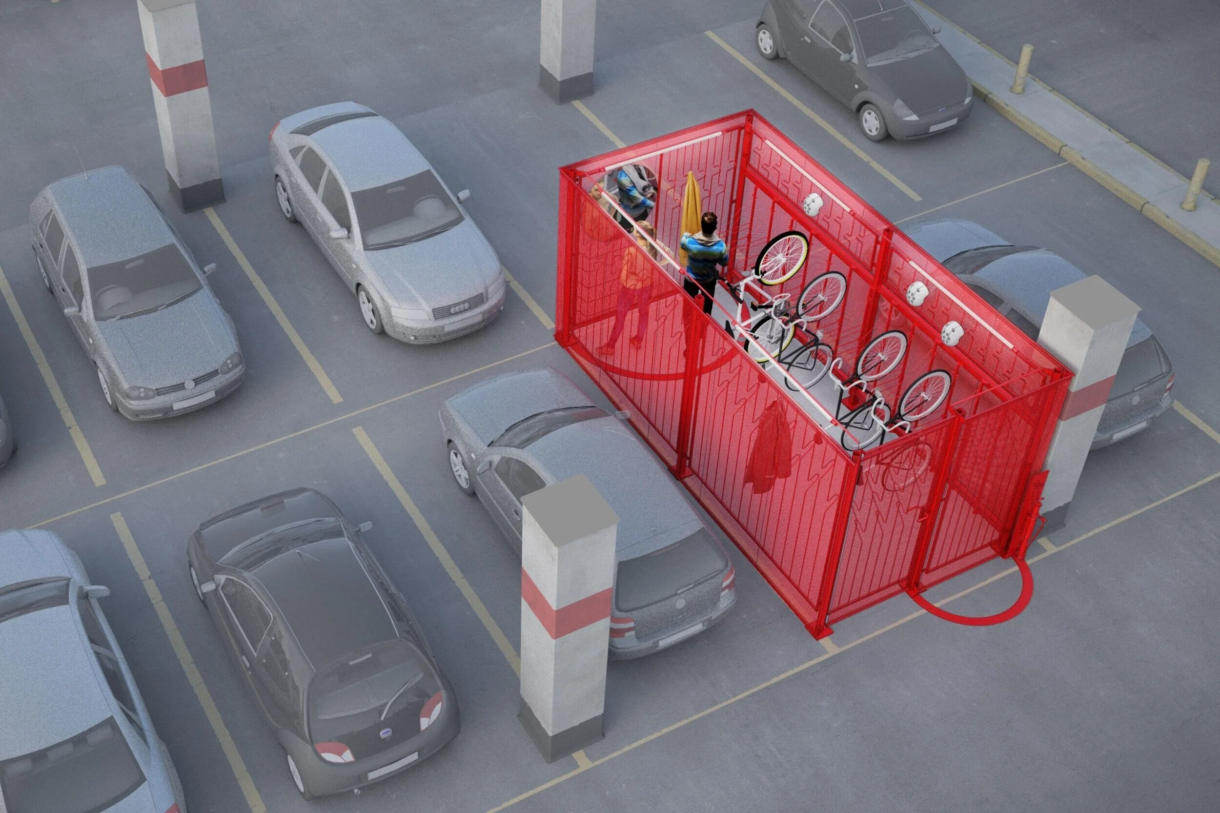
Bike2Box launched a modular bicycle parking box, which allows to transform a car parking slot into a locker accommodating 12 bicycles. It is designed to meet a growing demand in parking bicycles in post lockdown era, when people return to offices and seek for safe ways to commute. It’s quick, safe, uses existing spaces, does not require any mounting and can be rented for as long as needed.
The digital design specialist made this video in order to prepare medical staff in remote locations to respond to a possible spike in cases. Virtual reality is an immersive technology that benefits medical personnel by generating a 3D, interactive environment in settings that are often hard to simulate with 2D graphics. Through surgery on a mannequin, the video depicts a doctor treating a COVID patient suffering from respiratory failure.
The 'Seis-Foot cooler' from Heineken are at the minimum length distance the US Government advices people should stand from each other. They will be given away as part of an activation for the sub-brand Dos Equis’ social distancing drive to highlight social distancing guidelines, and will be available in the US from July 3rd while supplies last.
Microsoft's new global skills initiative aims at bringing more digital skills to 25 million people worldwide by the end of the year. Microsoft plans to combine existing and new resources from its LinkedIn and GitHub units (learning content, certifications, job-seeking tools), as well as from inside the rest of the company, and make them available for free or cheaply to those who are interested in upskilling or retraining for new careers.
The system has already been used to sanitise the Greater Boston Food Bank. In tests, the robot covered a 4,000 square foot area of the warehouse within 30 minutes, providing enough light to neutralise around 90% of COVID particles. Teleoperators have first to teach the robot a route around the site, then it follows waypoints around a map of the venue. The next step is enabling the robot to adapt to changes in its environment.
This new service will offer flexibility to passengers who will be able to order food and beverage from their own devices while socially distancing. Grab’s platform allows guests to order through a variety of digital channels and AtYourGate will facilitate retail purchases being delivered to customers' gate while waiting for their flight.
Thanks to this panel, called “Sparshless”, no one needs to touch elevator buttons anymore. According to the company, it can work with all existing lifts, no modification is required. Instead of disinfecting the lift everyday, this innovation could easily help stop the spread of the virus in appartments, hotels, malls, hospitals, offices and more places.
The campaign asks people who are about to share social media content to pause. The idea is for people to 'take care before you share", to try stop the spread of misinformation by enabling a personal behaviour change. The UN is working with social media platforms and technology companies on the campaign.
The senior living community, scheduled to open this fall at Oconomowoc, will have a very safe hospital-grade air purification system that is used by UW Hospital Madison and Mayo Clinic. The senior living community will also feature keyless locks, a video capable entrance system for visitors so residents can see who is visiting them, commercial laundry machines for a higher level of sanitation and a state-of-the-art whirlpool spa tub with FDA-recognized UV water purification system.
Mortimer’s app, BYEVID, enables Swedish drinkers to book their pub visit online, ahead of time, or to scan a QR code once in the bar, allowing owners to see if the venue has reached its safe capacity. Owners can vary the maximum number of customers, depending on the rules in their country. Information on what they do to keep the place clean during COVID will also be featured.
Organisations can engage Xenex’s team of experts on a project basis to utilize Xenex LightStrike Germ-Zapping Robots to kill harmful viruses, bacteria and spores that stay on commonly touched surfaces and pose a risk for disease transmission. The robot uses a xenon lamp to generate bursts of high intensity, broad-spectrum (200-315nm) ultraviolet light that’s more intense than sunlight, and is proven to destroy the virus that causes COVID, in two minutes.
At Hyperoom, customers can buy the products in 360-degree displays or in 2D closeups with product descriptions. All Diesel’s products will be featured in the virtual store through a customised section of the platform, including the Spring and Summer 2021 Collections. Diesel believes the new virtual-store concept will be a solution for many fashion brands as it also reduces the amount of clothing samples required in stores.
The website, EverydayExperiments.com, showcases a series of digital experiments that explore new ways of how we interact with the spaces we live in. It demonstrates how our homes can be experienced in extraordinary ways through the means of technology, focusing on AI, Machine Learning, Augmented Reality and cutting-edge Spatial Intelligence.


